Geotechnical surveying is an essential component within the construction industry, playing a critical role in ensuring the safety, stability, and longevity of structures. This comprehensive analysis of soil and rock properties aids engineers in making informed decisions about site selection, design, construction, and maintenance.
Understanding the Basics of Geotechnical Surveying
Geotechnical surveying, also known as soil investigation or site surveying, is a comprehensive process that involves the meticulous analysis of subsurface conditions at a proposed construction site. This includes identifying and characterising different types of soil, determining their composition, strength, and other pertinent properties. By gaining a deep understanding of these factors, engineers and construction professionals can make informed decisions that directly impact the design and execution of various construction projects. The knowledge of soil and rock properties plays a vital role in ensuring the safety, stability, and longevity of structures, as well as optimising construction techniques and materials. With careful consideration of geotechnical surveying findings, potential risks and challenges can be identified and mitigated, leading to successful and sustainable construction projects.
Relevance in the Construction Industry
Geotechnical surveying plays a crucial role in assessing the suitability of the land for construction, ensuring the right type of foundation is chosen for a building. By thoroughly examining the ground, it helps determine if it can bear the weight and withstand the demands of the proposed structure, significantly reducing the risk of structural failure. Moreover, this in-depth analysis also aids in identifying and addressing potential issues such as soil erosion, groundwater problems, and even seismic activity that may pose challenges to the project’s success. With its comprehensive approach, geotechnical surveying provides the necessary insights and recommendations to ensure a solid foundation and a successful construction endeavour.
The Geotechnical Surveying Process
The process of geotechnical surveying commences with a preliminary review of the selected site’s topographical and geological conditions through maps, aerial photographs, and satellite images. Local ground information, historical data, and existing structures in the vicinity are thoroughly studied.
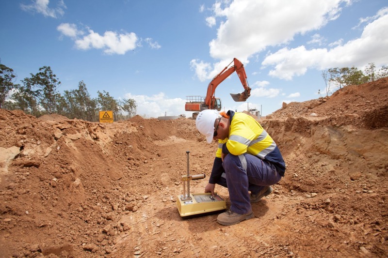
Upon gathering the necessary background data, field surveying is undertaken. This phase may involve several methods, including borings, cone penetration tests, and standard penetration tests, to evaluate the soil’s composition, strength, and other properties. These tests are conducted to identify the soil’s load-bearing capacity and to detect the presence of any water table, which may affect the structure’s stability.
Laboratory testing follows the field investigations. The collected soil samples are carefully studied for particle size, permeability, shear strength, and consolidation. The data derived from these tests provides a comprehensive understanding of the soil’s characteristics, which are crucial in the design and construction process.
The final step in the geotechnical surveying process is compiling a detailed report. This document illustrates the findings and recommendations based on the survey and lab tests, ensuring that the construction team has a clear understanding of the site conditions. The information provided is vital in making informed decisions about the project’s feasibility, design, construction techniques, and potential risk mitigation strategies.
Equipment Utilised in Geotechnical Surveying
Geotechnical surveying accuracy relies on specialised equipment. Tools like drilling rigs are used to collect soil samples and perform tests. Cone Penetration Testing (CPT) equipment measures soil resistance and provides insights into composition and density. Standard Penetration Test (SPT) equipment estimates soil bearing capacity. Vane shear test apparatus determines clay soil shear strength. In the lab, sieve shakers and hydrometers analyse particle size, while oedometers measure soil consolidation. Atterberg limits testing equipment measures fine-grained soil plasticity. These instruments aid in accurate data collection for construction planning.
Identifying the Need for a Geotechnical Survey
Understanding when a geotechnical survey is required can significantly influence the success of a construction project. The following are some key situations where a geotechnical survey becomes indispensable:
New Construction Projects: If a new structure is being planned, a geotechnical survey is a mandatory first step. This enables engineers to fully understand the ground conditions and determine if the site is suitable for the proposed structure, thus minimising the risk of future structural issues.
Structural Additions or Modifications: If a building is being extended or structurally modified, a geotechnical survey should be conducted. Even if a survey was performed at the time of the original construction, ground conditions might have changed, and the additional load may have an impact on the existing structure.
Suspected Ground Instability: If there is evidence of ground movement or instability such as subsidence, sinkholes or landslides in or around the site, a geotechnical survey will provide essential information about the underlying causes and help devise appropriate remedial measures.
Recurrent Structural Issues: If a building presents persistent structural problems like cracking, bowing or differential settlement, a geotechnical survey can help identify whether these are due to underlying soil or geotechnical issues.
Importance in Risk Management
Risk management is an essential and fundamental aspect of every construction project. One of the key tools used to mitigate risks associated with uncertain ground conditions is geotechnical surveying. This comprehensive process involves collecting and analysing detailed information about the properties of soil and rock. By understanding the specific characteristics of the ground, engineers can design structures with precision and accuracy, significantly reducing the likelihood of costly mistakes and potential catastrophic failures. Geotechnical surveying plays a vital role in ensuring the safety, stability, and long-term durability of construction projects.
Sustainability and Environmental Protection
Geotechnical investigations, as well as void detection ipswich also play a crucial role in safeguarding the environment. By conducting detailed studies on the soil composition and properties, developers gain valuable insights into how their constructions can coexist harmoniously with the surrounding ecosystem. This knowledge allows them to implement measures that minimise any potential adverse impacts, such as erosion control techniques and sustainable resource management strategies. Through these efforts, geotechnical investigations not only protect the environment but also contribute to the long-term sustainability of construction projects.
Conclusion
Geotechnical surveying is an indispensable aspect of the construction industry. It provides comprehensive insights into the ground conditions, ensuring the stability and safety of the structures built. The data derived from such comprehensive surveying is also influential in making informed decisions about design, construction techniques, and risk mitigation strategies. Furthermore, geotechnical investigations play a crucial role in sustainability and environmental protection, facilitating the implementation of measures to minimise the impact on the surrounding ecosystem. Thus, geotechnical surveying, with its meticulous process and specialised equipment, is pivotal to the success and longevity of any construction project.


